Home Home

 
Index...

Search this site:
Arts School, Ford Street
Bishop Street Post Office
Bishop Street, looking north
Bishop Street, looking south
Blue Coat School & ruins
Broadgate from Hertford Street
Broadgate from Holy Trinity Church
Burges from Bishop Street
Burges from Cross Cheaping
Burton's in Blitzed Broadgate
Butcher Row, Great
Butcher Row, Little
Cheylesmore Manor House
Coat of Arms Bridge
Cook Street gate
Council House
Cox Street
Far Gosford Street
Fire Station, Hales Street
Fleet Street
Ford's Hospital
Golden Cross & Pepper Lane
Greyfriars Lane
The Grove
Guildhall & 22 Bayley Lane
Hales Street
Hales Street to Corporation Street
Herbert Art Gallery & Museum
Hertford Street
Hertford Street from Broadgate
High Street aerial view
High Street from Broadgate
High Street from Earl Street
Hill Street, Bablake & Bond's
Hippodrome, New
Hippodrome, Old
Humber Motor Works
Ironmonger Row
Jordan Well & Earl Street
Jordan Well & Gosford Street
Kenilworth Road
Leamington Road
Much Park Street
Naul's Mill Park
Old Rope Walk
Opera House, Hales Street
Palace Yard
Pool Meadow from Priory Street
Precinct & Old Coventry aerial view
Precinct, upper
Precinct, west view
Priory Row
Priory Street, lower end
Priory Street, upper end
Queen Victoria Road flood of 1900
Railway Station - the platform
Railway Station, Eaton Road
Smithford Way
Spon End arches
Spon Street flood of 1900
St. John's Church, Fleet Street
St. Michael's Avenue
St. Michael's ruins
St. Michael's spire from Pepper Lane
Stoke Green & Pool
Swanswell Gate
Swanswell Pool
Swimming Baths, Priory Street
Trinity Church
Trinity Lane & the Free Library
Trinity Lane from Priory Row
Trinity Street aerial view
Trinity Street from Broadgate
Trinity Street from Hales Street
War Memorial Park
Warwick Road
Warwick Row, Hertford St & Warwick Lane
Well Street from Hales Street
West Orchard
Wheatley Street Schools
 

Palace Yard

Camera No. 30
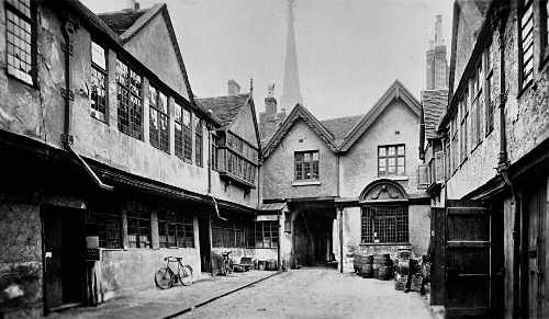
Palace Yard 1910

The "Palace Yard" photographed around 1910.
The narrow entrance to the yard in the centre of the picture leads through to Earl Street, directly opposite where the eastern end of the Council House now stands.
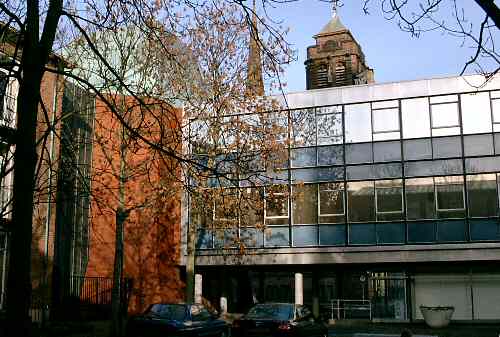
Palace Yard 2004

A view seen from the same place in 2004.
In addition to the spire of St. Michael's, the small tower of the Council House is now also visible against the skyline.

This photograph and the one below were taken by our six year-old son, Steven!
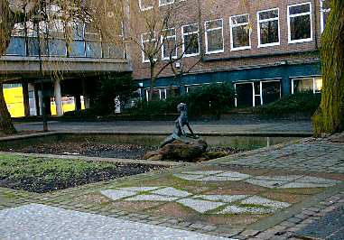
statue in Palace Yard 2004

The modern day image doesn't quite hold the same magic as the old one, does it? The one saving grace that the square used to have was that a glance to your right would have revealed a redeeming feature in the form of a pleasant bronze statue named "Naiad" made by a Coventry sculptor and former teacher, George Wagstaffe. (Who was teaching art at Stoke Park School while I was there in the 1970s.)
However, the statue was neglected here and in July 2004 was restored and moved to a more deserving and prominent position in Lady Herbert's Garden.

Until its complete destruction by a single high-explosive bomb during the 1940 blitz, the original Palace Yard had survived for around 400 to 600 years, and as the name suggests, has had Royal connections. One of the most significant events occurred in 1605 while the gunpowder plot was underway. Princess Elizabeth, whose father King James I had only been on the throne for two years, was living at Coombe Abbey, but when her life appeared to be under threat she was moved here for safe keeping. It was this event along with the visit and stay here of King James II in 1687 that led to the name "Palace Yard". Much more can be learnt about Palace Yard's Gunpowder Plot connection here.


Associated pages....
Home | How this site began | Bibliography | About me | My music | Discussion Forum | Steve's website | Historic Stoke, Coventry | Orland family website
Top of the page
3,301,934

Website by Rob Orland © 2002 to 2024