Home Home

 
Index...

Search this site:
1. Arts School, Ford Street
2. Bishop Street Post Office
3. Bishop Street, looking north
4. Bishop Street, looking south
5. Blue Coat School & ruins
6. Broadgate from Hertford Street
7. Broadgate from Holy Trinity Church
8. Burges from Bishop Street
9. Burges from Cross Cheaping
10. Burton's in Blitzed Broadgate
11. Butcher Row, Great
12. Butcher Row, Little
13. Cheylesmore Manor House
14. Coat of Arms Bridge
15. Cook Street gate
16. Council House
17. Cox Street
18. Far Gosford Street
19. Fire Station, Hales Street
20. Fleet Street
21. Ford's Hospital
22. Golden Cross & Pepper Lane
23. Greyfriars Lane
24. The Grove
25. Guildhall & 22 Bayley Lane
26. Hales Street
27. Hales Street to Corporation Street
28. Herbert Art Gallery & Museum
29. Hertford Street
30. Hertford Street from Broadgate
31. High Street aerial view
32. High Street from Broadgate
33. High Street from Earl Street
34. Hill Street, Bablake & Bond's
35. Hippodrome, New
36. Hippodrome, Old
37. Humber Motor Works
38. Ironmonger Row
39. Jordan Well & Earl Street
40. Jordan Well & Gosford Street
41. Kenilworth Road
42. Leamington Road
43. Much Park Street
44. Naul's Mill Park
45. Old Rope Walk
46. Opera House, Hales Street
47. Palace Yard
48. Pool Meadow from Priory Street
49. Precinct & Old Coventry aerial view
50. Precinct, upper
51. Precinct, west view
52. Priory Row
53. Priory Street, lower end
54. Priory Street, upper end
55. Queen Victoria Road flood of 1900
56. Railway Station - the platform
57. Railway Station, Eaton Road
58. Smithford Way
59. Spon End arches
60. Spon Street flood of 1900
61. St. John's Church, Fleet Street
62. St. Michael's Avenue
63. St. Michael's ruins
64. St. Michael's spire from Pepper Lane
65. Stoke Green & Pool
66. Swanswell Gate
67. Swanswell Pool
68. Swimming Baths, Priory Street
69. Trinity Church aerial view
70. Trinity Lane & the Free Library
71. Trinity Lane from Priory Row
72. Trinity Street aerial view
73. Trinity Street from Broadgate
74. Trinity Street from Hales Street
75. War Memorial Park
76. Warwick Road
77. Warwick Row, Hertford St & Warwick Lane
78. Well Street from Hales Street
79. West Orchard
80. Wheatley Street Schools
 

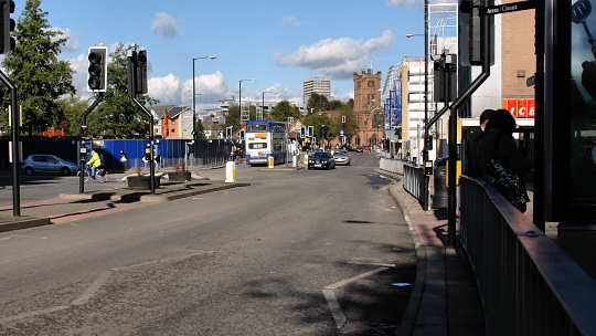
Queen Victoria Road flood of 1900

Camera No. 55

When the disastrous flood of 31st December 1900 occurred, Spon Street wasn't the only place to suffer. Property owners in nearby Queen Victoria Road were also subjected to misery, as can be seen in this postcard of the event.
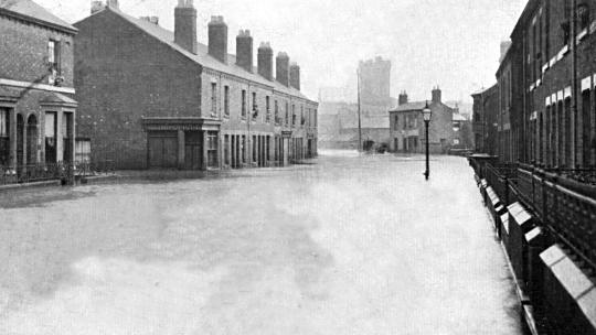
The flooding of Queen Victoria Road 31st December 1900
Queen Victoria Road in 2006

Apart from the distinctive tower of St. John's Church visible in the distance, there's nothing else to recognise this view by when comparing it with the one now seen in 2006. Croft Road, on the left, was no more than a side street a century ago, but now is primarily a link road through to the Ring Road or towards Earlsdon.

As I write this in December 2006, another change is shortly to take place. A large Ikea store is soon to be built on the corner beyond Croft Road.


Associated pages....
Home | How this site began | Bibliography | About me | My music | Discussion Forum | Steve's website | Historic Stoke, Coventry | Orland family website
Top of the page
3,809,598

Website by Rob Orland © 2002 to 2025